Ukraine says it struck the Russian missile ship Naro-Fominsk during its overnight operation against Ust-Luga on November 11. Its security service, the SBU, named the Buyan-M vessel in an official statement. The extent of damage remains unverified. Security Service of Ukraine, official Telegram statement.
Estonia observed an explosion, smoke and a vessel moving back toward St. Petersburg under its own power. Defence Minister Martin Herem told ERR that Estonia could not confirm whether the cause was a Ukrainian attack or an accident. That limitation matters when assessing Kyiv’s claim. ERR interview with Estonian Defence Minister Martin Herem.
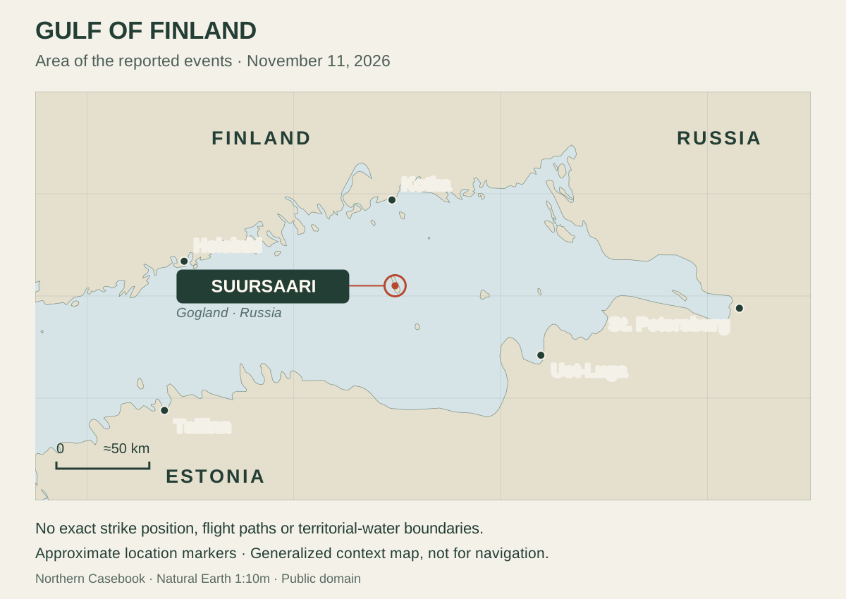
Yle reported that a senior Finnish official also confirmed a Finnish observation near Suursaari, the Russian island also known as Gogland. NCB has not independently verified the strike location or damage. The immediate public question is how civilian traffic is protected while authorities establish what happened. Yle, report on the warship incident near Suursaari.
Several events share a night, but their links need evidence
The SBU said its operation hit oil and port infrastructure at Ust-Luga and included a planned strike on the warship. It described Naro-Fominsk as a carrier of Kalibr and Oniks missiles and said it was launched in 2022. Launching is different from entering naval service; the statement does not establish what weapons were aboard that night. Security Service of Ukraine, official Telegram statement.
Finland’s Defence Ministry reported a suspected drone incursion after 2 a.m., lasting about five minutes, according to STT. The Border Guard is investigating. The ministry did not identify the drone’s origin in that account. The suspected Finnish incursion cannot yet be linked to the same aircraft or route as the claimed ship strike. STT via Suomenmaa, suspected Finnish airspace violation.
Herem placed the ship explosion at about 5:30 a.m. on November 11. Finland and Estonia use the same time zone in November: that is 4:30 a.m. in Oslo and 10:30 p.m. on November 10 in New York. These times identify reported observations, not a reconstructed flight path. ERR, report of explosion on Russian warship.
Finnish authorities temporarily restricted air and sea traffic in the eastern gulf. Lentoposti reported that the restrictions were lifted at about 7:20 a.m. Finnish time. Their imposition was a precaution; their removal does not establish a permanent absence of drone risk. Lentoposti, suspected airspace violation.
A busy sea needs a shared picture
Suursaari is roughly 40 kilometers from Kotka, according to Yle’s geographical account. This brings the incident close to Finnish coastal communities, but distance from an island to a city is not the distance from an unverified impact point to a national boundary. Maria Stenroos, Yle analysis of Gulf of Finland incident.
Commercial navigation here is already organized to reduce risk. Fintraffic describes the Gulf of Finland Reporting system, GOFREP, with Finnish, Estonian and Russian areas of responsibility. Traffic separation schemes direct opposing flows along different routes. Those arrangements explain why a military incident can have consequences for mariners beyond the vessel involved. Fintraffic, monitoring international waters in the Gulf of Finland.
Fintraffic’s vessel traffic services provide information, warn of developing dangers and organize traffic. The ship’s master retains responsibility for navigating. A warning must therefore reach a bridge in a form that a crew can use: the affected area, the period of validity and the official instruction. Fintraffic, About Vessel Traffic Services.
The available reports do not establish a collision, a casualty aboard a commercial ship or a wider interruption of Baltic trade. Nor do they establish a quantified bill for the response. Those outcomes should not be written into the story simply because a tanker route and a military operation occupy the same sea.
A decision not to shoot can also be a safety decision
Herem said Turkish NATO aircraft were airborne, but engagement was unsafe near Russia. Estonia had not permitted use of its airspace. This does not establish Finland’s reasoning or an approved corridor. ERR interview with Estonian Defence Minister Martin Herem.
The operational test is broader than whether a weapon was fired. Authorities must distinguish an object’s identity, trajectory and immediate danger from the possible effects of interception. An account of one night cannot establish that a different engagement would have been safer. Public accountability requires explaining the decision as far as security permits, without inventing details absent from the record.
Near NATO is not an Article 5 finding
NATO describes Article 5 as a collective-defence obligation following an armed attack against an ally, assessed case by case. A reported Ukrainian strike on a Russian warship does not, by geographical proximity alone, establish that condition. An airspace incursion still requires investigation and a sovereign response. NATO, collective defence and Article 5.
The useful follow-up is concrete: the Border Guard’s findings on the Finnish incursion, independently supportable evidence of damage to the ship, and a clear account of warnings and restrictions affecting civilian traffic. An explanation of how the response was coordinated would help readers assess readiness. It would not require disclosure of patrol positions or defensive tactics.
Russia’s war against Ukraine is the setting for these strikes. For Finland and Estonia, the task is to protect people using the gulf while keeping the distinction between observation, attribution and speculation intact. The region’s safety is not measured by the drama of a video. It is measured by whether crews and coastal communities receive usable protection.